Fishing Within 27km of Swansea Heads Towards Norah Heads
Fishing Out of Swansea Heads: Marks 23 to 30
The southern end of the run, and the last of the marks within reach of a fishing day trip out of Swansea. Everything here sits off Norah Head and the coast running north from it — eight marks between 20 and 27 kilometres from the bar, most of them tucked in close to a coastline that has been wrecking ships since the 1830s.
These are long steams for close-in ground. Six of the eight sit within three kilometres of the beach. What you’re buying with the fuel is a stretch of coast with more structure than anywhere else in this series: reef that breaks the surface, ledges, gutters and drop-offs, all of it swept by current running past a headland that juts hard into the Tasman.
Positions come from the Marine Rescue Lake Macquarie fishing matrix. Distances have been recalculated from the coordinates — the published column runs about half a kilometre optimistic across this whole group, consistently rather than randomly, which suggests it was measured from a slightly different origin rather than being wrong per se.
Before you read the numbers
Depths here are estimates. Unlike earlier parts in this series, we don’t have charted figures for these marks. The depths below are inferred from the shelf profile and from how far offshore each mark sits, and they’re flagged as estimates throughout. Sound them yourself — and if you have real numbers, we’d like them.
This is an exposed coast. Norah Head takes swell from the north-east through to the south, and the marks close inshore here are shallow rock in moving water. That combination is what makes them fish and what makes them dangerous. Read the safety section before you plan a trip around the inshore ones.
Quick reference
| # | Mark | Position | From Heads | Offshore | Depth* | Bottom | Main species |
|---|---|---|---|---|---|---|---|
| 23 | Paddy’s Reef | 33° 15.90′ / 151° 35.20′ | 20.4 km | 1.5 km | 15–25 m | Inshore reef | Snapper, morwong, trevally |
| 24 | Drop Off Ground | 33° 16.60′ / 151° 36.00′ | 21.2 km | 1.8 km | 20–35 m | Contour break | Snapper, kings, mulloway |
| 25 | First Traps | 33° 17.12′ / 151° 37.58′ | 21.7 km | 4.2 km | 30–45 m | Reef and rubble | Snapper, morwong, perch |
| 26 | Cunning Reef (North) | 33° 18.20′ / 151° 37.60′ | 23.6 km | 4.8 km | 35–50 m | Hard reef | Snapper, kings, trag |
| 27 | Trap Reef | 33° 18.30′ / 151° 35.80′ | 24.4 km | 2.6 km | 25–40 m | Reef | Snapper, morwong |
| 28 | Cunning Reef (Middle) | 33° 19.00′ / 151° 37.60′ | 25.1 km | 5.6 km | 40–55 m | Hard reef | Snapper, trag, kings |
| 29 | Green Hills | 33° 18.30′ / 151° 34.20′ | 25.1 km | 0.9 km | 10–20 m | Shallow reef | Snapper, bream, salmon |
| 30 | The Shallows | 33° 19.20′ / 151° 34.20′ | 26.7 km | 2.5 km | 15–25 m | Shallow reef | Snapper, trevally, kings |
* All depths estimated from the shelf profile, not charted. Sound before you commit.
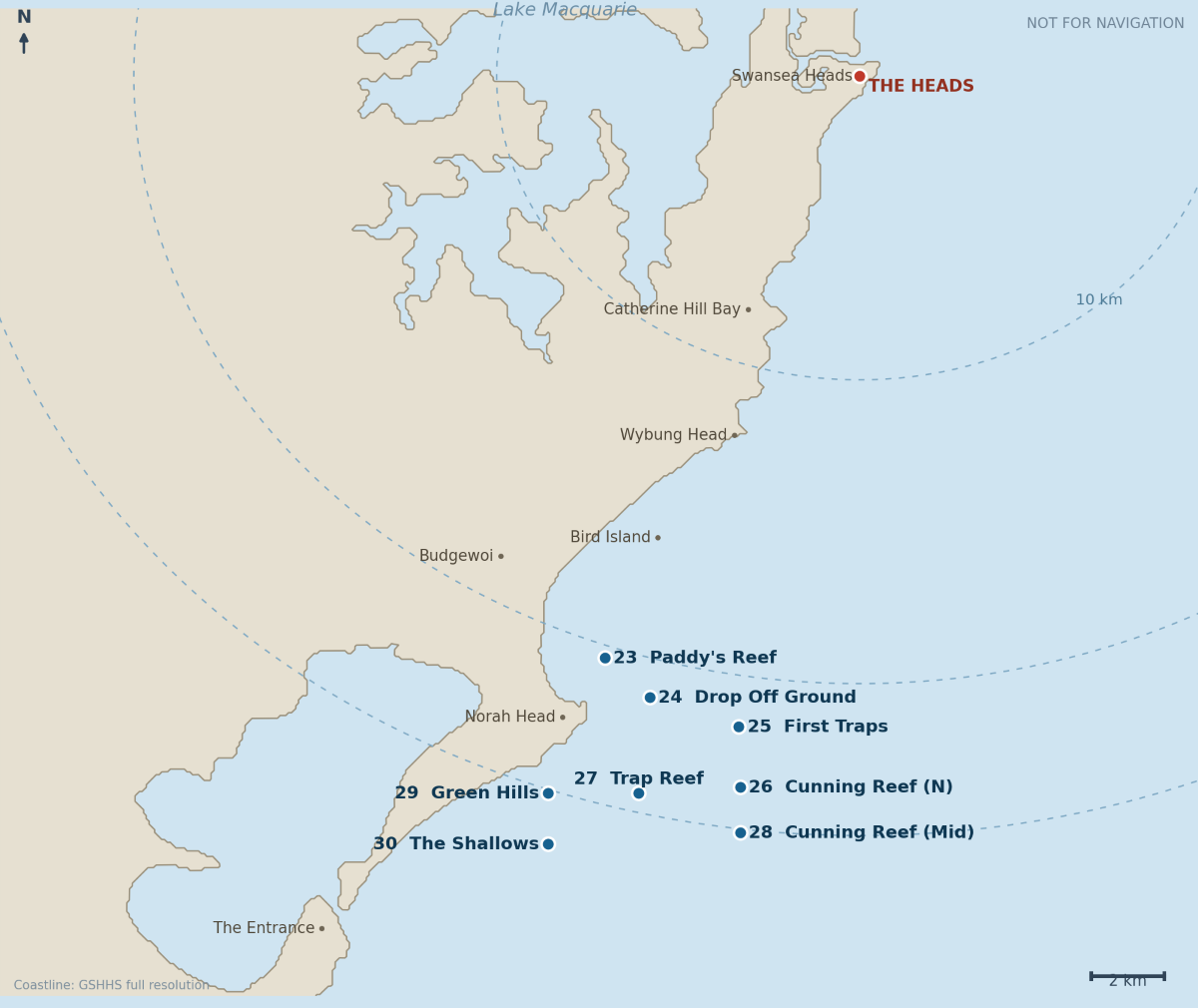
The marks on a map
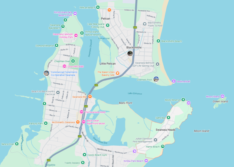
Rings are 10, 20 and 25 km from the Heads. The chain running south from Paddy’s Reef to the Shallows is unmistakable — no mark in this group is more than three kilometres from its neighbour, which makes the whole thing fishable as a single day working down the coast rather than as eight separate destinations.
23. Paddy’s Reef — 20.4 km
33° 15.90′ S, 151° 35.20′ E · 20.4 km from the Heads · 1.5 km offshore · est. 15–25 m
The northernmost of the Norah Head group and the closest to home, sitting a kilometre and a half off the coast between Budgewoi and Norah Head.
This is inshore reef on a coast built from Triassic sedimentary rock — the same conglomerate and lithic sandstone that outcrops at Norah Head and along the Wybung and Frazer Beach cliffs. That rock weathers into blocky ledges, undercuts and jointed faces rather than smooth boulders, which is why the reefs along this stretch hold fish so well: there are places to hide.
Target species: Snapper and squire over the reef, morwong on the rock itself, silver trevally through the water column, bream in the broken ground, tailor and salmon through the cooler months.
Baits and rigs: Anchor up-current and berley — at this depth a good trail does more work than any rig refinement. Unweighted or lightly weighted baits drifted back through it. Fresh squid, pilchard, whole prawns. Soft plastics work well over the reef edges.
Best time: Winter and spring for snapper. A bit of swell and colour in the water improves it. Flat, clear conditions after westerlies generally mean a slow day and a lot of pickers.
24. The Drop Off Ground — 21.2 km
33° 16.60′ S, 151° 36.00′ E · 21.2 km from the Heads · 1.8 km offshore · est. 20–35 m
The name is the mark. Somewhere here the bottom falls away, and that contour break is what you’re fishing — not the shallow side, not the deep side, but the edge itself and the water immediately over it.
Drop-offs work because they concentrate everything. Current hits the rise and deflects upward, carrying nutrients with it. Bait stacks against the edge. Predators sit below and behind it, waiting for whatever comes over. On a sounder it should be obvious: a clear step in the bottom trace, often with bait showing above it.
Target species: Snapper hold on the edge and just below it. Kingfish patrol the top of the drop where the current accelerates. Mulloway sit deeper against the base, particularly at night and around the tide change. Morwong and trevally over the harder ground either side.
Baits and rigs: Position up-current of the edge and let baits drift over it — that’s the natural presentation and it beats dropping straight down onto the fish. Unweighted or lightly weighted for snapper. Live bait or jigs for kings working the top. If you’re after mulloway, fish heavier and deeper against the base of the drop after dark.
Best time: Fish the tide change, which is when the current across the edge is doing the most work. Winter and spring for snapper, summer for kings, night sessions for mulloway.
25. First Traps — 21.7 km
33° 17.12′ S, 151° 37.58′ E · 21.7 km from the Heads · 4.2 km offshore · est. 30–45 m
Further out than its neighbours and the first of two marks on this list carrying the Traps name — Trap Reef sits 2.8 kilometres south-west. The “first” suggests a sequence worked from north to south, which is how you’d naturally run this coast from Swansea.
We haven’t been able to confirm where the name comes from. The most plausible reading is commercial trap fishing: NSW runs an Ocean Trap and Line Fishery targeting snapper, kingfish, leatherjacket, bonito, silver trevally and rubberlip morwong along the shelf, and demersal fish traps are one of its main methods. Ground worked by trap boats picking up a name from the practice would be entirely ordinary. That’s inference, not established fact — if you know the real origin, tell us.
Target species: At this depth and distance, snapper, morwong, silver trevally and ocean perch over the reef and rubble, with kingfish through the water column when current and bait are up.
Baits and rigs: Paternoster with fresh squid, pilchard or fish strip for the mixed bag. Drift rather than anchor unless you’ve marked a specific lump — the reef and rubble here will take gear from a boat sitting in one place.
Best time: Autumn through winter for the reef species. Being four kilometres out it stays workable when the inshore marks are churned up, which makes it a useful fallback on a marginal day.
26 and 28. Cunning Reef, north and middle — 23.6 and 25.1 km
33° 18.20′ S, 151° 37.60′ E (north end)
33° 19.00′ S, 151° 37.60′ E (middle)
23.6–25.1 km from the Heads · 4.8–5.6 km offshore · est. 35–55 m
Two marks on identical longitude, 1.5 kilometres apart on a north–south line. The names do the explaining: these are two points on one reef system running along the shelf, and the fact that someone bothered to distinguish “north end” from “middle” means it’s big enough to be worth knowing where you are on it.
That also implies a southern end nobody has given us numbers for. Worth prospecting if you’re down here with time.
This is the furthest offshore ground in this article and the deepest. Hard reef in current-swept water on the shelf, with the middle mark noticeably deeper than the north end — the system runs downhill as it goes south.
Target species: Snapper, and the deeper water here should produce better fish than the inshore marks. Teraglin over the reef, particularly from late afternoon into the evening. Kingfish through the water column. Morwong, ocean perch and silver trevally on the structure.
Baits and rigs: Paternoster rigs with enough lead to hold in current. Fresh squid, whole pilchard, strip baits. Slow-pitch and knife jigs work well over hard reef at this depth. Work the north end first and move south if it’s quiet — you’re covering one system, not relocating.
Best time: Winter and spring for snapper, late afternoon into evening for trag, summer for kings. Needs a settled forecast: five kilometres offshore at the far end of a 25-kilometre run is not a place to be caught by a building sea.
27. Trap Reef — 24.4 km
33° 18.30′ S, 151° 35.80′ E · 24.4 km from the Heads · 2.6 km offshore · est. 25–40 m
Two point eight kilometres south-west of First Traps and clearly related by name, though whether they’re two parts of one ground or two separate pieces of reef isn’t something we can settle from the numbers alone. They sit at different depths and different distances offshore, so treat them as separate stops until your sounder tells you otherwise.
Reef bottom in the middle depth band, closer inshore than the Cunning Reef marks and deeper than Green Hills. It’s a sensible mid-morning stop on a day working down this coast.
Target species: Snapper and squire, morwong, silver trevally, ocean perch. Kingfish in the warmer months.
Baits and rigs: Paternoster for the mixed bag, or berley and float baits if you find a piece of reef worth anchoring up-current of. Fresh bait matters more than rig sophistication here.
Best time: Autumn through winter. Fish the tide change.
29. Green Hills — 25.1 km
33° 18.30′ S, 151° 34.20′ E · 25.1 km from the Heads · 0.9 km offshore · est. 10–20 m
Read that offshore figure before you plan anything. Green Hills sits 900 metres off the beach south of Norah Head — the closest inshore mark in the entire series, and shallow with it.
The name almost certainly comes from a shore lineup, which is how marks this close in were found before GPS: line up two features on the land and hold the transit. It suggests the mark predates plotters, and that it’s been fished for a long time.
Shallow reef in moving water directly off an exposed stretch of coast. This is a small-boat proposition on a good day and a genuinely bad idea on a poor one. Norah Head takes swell from north-east right around to south, and there’s very little between this mark and the rocks.
Target species: Snapper and squire in the wash, bream, silver trevally, drummer off the adjacent rock, tailor and salmon in season. Big rays and wobbegongs are regular company at this depth.
Baits and rigs: Light gear and berley. Unweighted baits in the wash, prawns, squid strips, pilchard. Plastics cast into the foam lines. Heavy bottom rigs are the wrong approach in ten metres of moving water.
Best time: Winter for snapper and drummer, spring for bream. Needs an offshore breeze and a low swell. If there’s any east in the swell, go somewhere else — this is a lee shore with rock on it.
30. The Shallows — 26.7 km
33° 19.20′ S, 151° 34.20′ E · 26.7 km from the Heads · 2.5 km offshore · est. 15–25 m
The southernmost mark in the series and the end of the road for a day trip out of Swansea. It sits 1.7 kilometres south of Green Hills on the same longitude, a little further offshore and a little deeper — the two are probably parts of the same shallow reef system running south past Norah Head.
Despite the name it’s not as shallow as Green Hills, and the extra distance off the beach makes it the safer of the two in anything but flat conditions.
Worth knowing what’s nearby: the Bull Rocks, a large reef that breaks the surface, sit roughly a kilometre from the Cabbage Tree Harbour boat ramp directly off Norah Head, with a wall on the seaward side running north-west to south-east. There are several reef systems in this general area and parts of them are current-affected. If you’re fishing the Shallows you’re in that country.
Target species: Snapper over the reef, silver trevally, morwong, bream. Kingfish patrol the deeper edges and current breaks. Tailor and salmon in the cooler months. Flathead on the sand lanes between the reef patches.
Baits and rigs: Berley and drift baits over the reef. Plastics on the edges and through the sand lanes. Live yakkas or metal slugs for the kings working the current breaks.
Best time: Winter and spring for snapper, summer for kings. A moderate swell helps; a big one makes the whole area untenable.
Safety on this stretch
This coast has a wrecking history for a reason. Norah Head Lighthouse was built in 1903 — the last significant lighthouse constructed in New South Wales — after considerable numbers of ships foundered on the coast near the headland. The 63-metre tower exists because this stretch kept killing people. That history is worth carrying in your head when you’re deciding whether the swell is workable.
The inshore marks are the dangerous ones. Green Hills at 900 metres and Paddy’s Reef at 1.5 kilometres are shallow rock on an exposed lee shore. In easterly swell they are not fishable, no matter how good the forecast looked at the ramp. Deep water is safer than shallow water near rocks, every time.
Watch the return leg. Every mark here is over 20 kilometres from the Heads and the southernmost is nearly 27. A nor’easter that builds through the afternoon turns that into a long punch home into a head sea. Plan fuel and timing on the trip back, not the trip out.
Log on and log off. Marine Rescue Lake Macquarie holds a 24-hour watch on VHF 16 from the base at Swansea Heads. On runs this long, at this end of their range, it matters more than usual. Consider whether a Central Coast unit is better placed to hear you at the southern marks.
Cabbage Tree Harbour has a boat ramp at Norah Head, which is worth knowing about for two reasons: it’s a much shorter run to these marks if you’re prepared to trailer south, and it’s a bolt-hole if conditions deteriorate while you’re at the southern end.
Sound before you fish. None of these depths are charted. If your sounder disagrees with the estimates in this article, believe your sounder.
Useful links
- Norah Head Lighthouse — the 1903 tower, why it was built, and the losses that prompted it.
- NSW Ocean Trap and Line Fishery — the commercial fishery working this shelf, and the likely origin of the Traps names.
- Norah Head dive sites — the Bull Rocks and the reef systems around the headland, described by divers who’ve been on them.
- Beachsafe: Norah Head and Soldiers Beach — the rocky shores and reefs south of the head, and current surf conditions.
- Norah Head visitor information — ramps, access and the Cabbage Tree Harbour facilities.
- Marine Rescue Lake Macquarie fishing matrix — the source list for these positions.
Next in the series
That completes the marks running north and south of Swansea Heads. What’s left is the Farm — eleven sets of numbers spread across one ground eight kilometres wide, with the worst distance errors in the whole matrix. It gets its own article.
Positions sourced from the Marine Rescue Lake Macquarie fishing matrix and reproduced with their caveat: not for navigation. Distances recalculated from coordinates; depths estimated, not charted. Log on with Marine Rescue Lake Macquarie on VHF 16 before you cross the bar, and log off when you’re back.