8 Sensational Fishing Marks Less Than 7km Off Swansea Heads
Every trailer boat that clears Swansea Heads faces the same question: how far do I have to run before I’m on fish? The answer, more often than most people admit, is “not very.” Every fishing mark in this article sits within 11 km of the entrance, and several are productive grounds that get run straight past by boats heading wide.
Positions come from the Marine Rescue Lake Macquarie fishing matrix. Their own caveat is worth repeating: the coordinates supplied should not be used for navigation. Depths and seabed detail have been cross-checked against Navionics chart data, and where the two sources disagree, both figures are given.
Before you read the numbers
Distance from the Heads is not distance offshore. This trips people up constantly. Red’s, at Catherine Hill Bay, is 7.1 km from Swansea but only about 1.7 km off the beach. Surf Club Gravel is 8.0 km from the Heads and 1.4 km off Redhead. A long steam number doesn’t mean a rough, exposed, wide-water proposition — it often just means you’re running parallel to the coast. Each entry gives both figures.
Charted depths are to lowest astronomical tide. That’s the reference datum, so on most days you’ll be sounding a metre or two more than the chart shows. Where a figure is an inference rather than a charted reading, it says so.
Quick reference
Distances are from Swansea Heads. Depths are charted to lowest astronomical tide, so expect a metre or two more on the day.
| # | Mark | Position | From Heads | Offshore | Depth | Bottom | Main species |
|---|---|---|---|---|---|---|---|
| 1 | Flathead | 33° 04.54′ / 151° 42.91′ | 5.0 km | 5.0 km | 30–40 m | Sand, reef patches | Flathead, snapper |
| 2 | Swansea Gravel | 33° 05.57′ / 151° 43.38′ | 5.4 km | 6.2 km | 40–50 m | Gravel, shell | Snapper, trevally |
| 3 | Moon Island Wreck | 33° 05.53′ / 151° 43.45′ | 5.5 km | 6.3 km | 35–50 m* | Iron wreck on sand | Snapper, kingfish |
| 4 | North East Farm | 33° 07.55′ / 151° 43.08′ | 6.4 km | 6.6 km | 40–50 m | Sand, shell grit | Flathead, whiting |
| 5 | Red’s / Gubbs | 33° 09.13′ / 151° 39.30′ | 7.1 km | 1.7 km | 30 m | Sand | Flathead, rays |
| 6 | Redhead Pinnacle | 33° 02.13′ / 151° 43.34′ | 8.0 km | 1.4 km | 20–30 m† | Hard reef, relief | Snapper, kingfish |
| 7 | Redhead Gravel | 33° 01.07′ / 151° 44.20′ | 10.4 km | 2.9 km | 30–40 m† | Gravel, shell | Mixed bag |
| 8 | Advance Wreck | 33° 10.84′ / 151° 42.20′ | 10.9 km | 6.6 km | 45–55 m | Wreck on sand | Snapper, pearl perch |
* Sources disagree — see the entry. † Estimated, not charted.
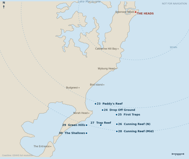
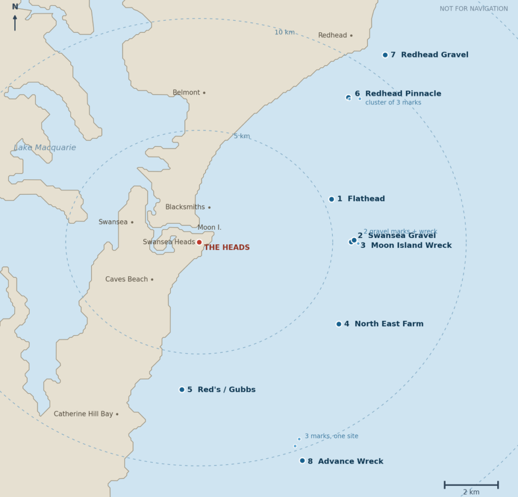
The marks on a map
The rings are 5, 10 and 15 km from the Heads. Notice how little the steam distance tells you about how far out you’ll be: Red’s and the Redhead pinnacles are both a long way around the coast but sit almost on the beach, while the Advance is barely further in steaming terms and sits nearly 7 km offshore.
1. Flathead — 5.0 km
33° 04.54′ S, 151° 42.91′ E · 5.0 km from the Heads · approx. 5.0 km offshore · 30–40 m charted, 45 m maximum (LAT)
The closest mark on the list and the one most likely to put a feed in the esky on a marginal day. Sand bottom with reef patches through it — enough structure to hold fish, not enough to cost you rigs all morning.
There’s a useful reference point nearby. The Newcastle Offshore Artificial Reef sits about 1.4 km north-west, and DPIRD describes that site as a sandy area roughly 3.5 km north-east of the Swansea bar in 28 metres. The Flathead mark sits further out and south-east, which is exactly the depth progression the chart confirms.
Target species: Sand and tiger flathead as the mainstay, the odd gurnard, sand whiting on the shallower western edge, and snapper working the reef patches — those patches are where a mixed-bag drift turns into something better.
Baits and rigs: A two-hook paternoster is all this ground asks for. Pilchard cubes, squid strips, whitebait. For a better class of flathead, a whole squid head or a strip bait on the bottom hook. Soft plastics in the 4–5 inch range work well on a controlled drift. Mark the reef patches as you cross them and drift them repeatedly rather than covering new sand each pass.
Best time: Year-round, with flathead most reliable spring through autumn. Work it on a light drift — if you’re moving too fast, motor back up rather than fighting it with more lead.
Worth knowing: The artificial reef is a legitimate bonus stop. DPIRD lists kingfish, snapper, silver trevally, mulloway, yellowtail scad and blue mackerel for these structures, and Swansea reports have included snapper, silver trevally, blue-spotted flathead, pearl perch and kingfish. Drift the tower edges rather than anchoring on the structure — it’s 12 metres of steel and it will keep your anchor.
2. Swansea Gravel — 5.4 km
33° 05.57′ S, 151° 43.38′ E (western marker)
33° 05.61′ S, 151° 43.55′ E (eastern marker)
5.4 km from the Heads · approx. 6.2 km offshore · 40–50 m charted, last surveyed 2020
Two separate markers carry this name, roughly 270 metres apart, and the Moon Island wreck sits between them. That arrangement tells you something useful: the gravel is the ground surrounding the wreck, and the whole area is one fishable complex rather than three unrelated stops. Plan a session here, not three separate runs.
Gravel and shell beds over a generally low-relief bottom. It holds worms, crabs and small crustaceans, which holds foraging fish. It’s not a jagged high-profile reef and shouldn’t sound like one.
One warning if you research this mark yourself: Swansea Bay in Wales generates an enormous volume of seabed survey material — tidal lagoon studies, Natural Resources Wales reports, British Geological Survey mapping — and it badly contaminates search results. Several AI-generated summaries of “Swansea Gravel” seabed composition are quietly citing Welsh geology. Our Swansea is on the other side of the planet.
Target species: Snapper and squire over the rubble, flathead on the sand edges, silver trevally, morwong, the occasional pearl perch.
Baits and rigs: Paternoster for a mixed bag. For snapper, drop back to a lightly weighted or unweighted bait — half a pilchard, fresh squid strip, a slab of slimy mackerel — drifted down through a berley trail. Fresh bait beats frozen here by a wide margin.
Best time: Autumn and winter for snapper. Local reports note good runs of inshore snapper off Swansea in autumn. Summer brings bonito and the odd kingfish through.
3. Moon Island Wreck — 5.5 km
33° 05.53′ S, 151° 43.45′ E · 5.5 km from the Heads · approx. 6.3 km offshore · 40–50 m charted; dive records say 35 m
Note that depth disagreement and sound carefully. Navionics charts this area at 40–50 m, but published wreck records place the site in 35 m. Either the wreck sits on a shallower rise within the deeper surrounding ground, or one source is out. Worth knowing before you rig.
The wreck itself has a name and a story. It’s the Bonnie Dundee, an iron steamer of 193 tons gross built in Dundee in 1877. On 10 March 1879 she was rammed by the SS Barrabool off Lake Macquarie and sank within a few minutes, taking four passengers and a cabin boy with her.
She’s sinking into the sand, with the engine and boiler standing proud. That’s your fish-holding structure: a compact, high-relief lump of iron sitting in the middle of the Swansea Gravel beds.
Target species: Snapper, morwong, silver trevally, bullseyes and pomfret in clouds over the structure, kingfish patrolling above in the warmer months. Wobbegongs are a near-certainty around any iron on sand along this coast.
Baits and rigs: Anchor up-current and berley, or drift across the top. Chasing kingfish, run a live yellowtail or slimy under a float, or work a jig over the boiler. Expect to lose terminal tackle and fish it with that priced in.
Best time: Winter into spring for snapper, summer for kings. Needs a light swell and workable current.
A word on the wreck: historic shipwrecks in NSW waters are protected. Fish it, don’t salvage it.
4. North East Farm — 6.4 km
33° 07.55′ S, 151° 43.08′ E · 6.4 km from the Heads · approx. 6.6 km offshore · 40–50 m charted
The northernmost outlier of the Farm complex, far enough from the main Farm grounds to be treated as its own stop.
The seabed here is soft sediment — fine to coarse marine sand, broken shell, and patches of silt. The broader area is a relatively flat, shelving underwater plain of sand swept along the coast by tidal movement and the East Australian Current. Interspersed through it are heavier fragments of shellfish and old bivalve beds. That coarse shell grit is the key: it provides just enough topography to hold marine life without snagging heavy nets, which is why the ground has historically been favoured as clean commercial trawling country.
There may also be intermittent low-lying indurated sand extensions — what gets called coffee rock locally — or small rubble patches. What you won’t find is the vertical structure of the high-relief reef closer inshore around Redhead. This is a flat-country mark.
Target species: Because the bottom is flat sand and soft grit rather than reef peaks, the fish here are the ones that bury and ambush: flathead and school whiting predominantly, with snapper and morwong moving across the shell grit patches, and silver trevally through the water column.
Baits and rigs: Paternoster with squid and pilchard. Octopus legs are hard to beat if you can get them and they stay on the hook when the pickers move in. This is drift country, not anchor country, unless you’ve marked a specific shell grit patch worth sitting on.
Best time: Autumn through winter for the reef species, year-round for flathead. Fish the tide change.
Data note: this mark appears twice on the Marine Rescue list, once at 6.4 km and once at 17.6 km, with identical coordinates. The 6.4 is correct.
5. Red’s, also known as Gubbs — 7.1 km
33° 09.13′ S, 151° 39.30′ E · 7.1 km from the Heads · approx. 1.7 km offshore · 30 m charted
Let’s be honest about this one, because plenty of guides won’t be. Red’s — known locally as Gubbs — is a sand bottom in 30 metres and the reliable catch is flathead, sharks and rays. It is not the inshore snapper reef its position and reputation might suggest, and anglers who arrive expecting one tend to leave frustrated.
That doesn’t make it worthless. It makes it a specific tool for a specific job. At 1.7 km off the beach it’s a genuine small-boat option on a day when going wide isn’t sensible, and if you want a feed of flathead without a long run, it will deliver. Go there wanting flathead and you’ll have a good day. Go there wanting snapper and you’ll waste a tank of fuel.
Target species: Flathead, with sharks and rays as regular and often unwelcome company. The rays in particular will find your bait before anything else does.
Baits and rigs: Standard flathead drift. Paternoster, pilchard and squid, or plastics. Don’t invest in an elaborate berley trail — you’ll mostly be feeding rays.
Best time: Spring through autumn for flathead. If you’re getting picked apart by rays, move rather than persist.
6. Redhead Pinnacle and Surf Club Gravel — 8.0 to 8.2 km
33° 02.09′ S, 151° 43.31′ E (Surf Club Gravel)
33° 02.13′ S, 151° 43.34′ E (Redhead Pinnacle)
33° 02.12′ S, 151° 43.59′ E (Redhead Pinnacle, eastern numbers)
8.0–8.2 km from the Heads · 1.4–1.9 km offshore · est. 20–30 m
Three entries on the Marine Rescue list, but the first two are 88 metres apart — closer together than a decent drift. The third sits about 390 m east. Treat it as one ground with several sets of numbers: different boats, different years, same reef.
The bottom here is genuinely different from everything else in this post, and it’s why the mark is worth the run. This is the one high-relief ground on the list. Redhead Bluff is a resistant Permian outcrop, and the offshore pinnacles are almost certainly the same rock continuing seaward beneath the sand veneer, standing proud where the sand hasn’t buried it. Expect hard bottom with genuine vertical relief, grading into the gravel and rubble that gives Surf Club Gravel its name. That grading is the pattern to fish: rubble apron surrounding hard structure, with the transition edge holding the fish.
The relief itself is the number worth having and it isn’t well published. Sound it and note the difference between the pinnacle top and the surrounding bottom — that figure will tell you more about how the mark fishes than the depth alone.
Target species: Snapper is the headline act, and this is the closest reliable snapper reef to Swansea. Also morwong, silver trevally, pearl perch, kingfish in summer, salmon and tailor through the colder months.
Baits and rigs: Anchor up-current of the pinnacle and berley hard. Fresh baits with minimal weight, drifting naturally down the trail, will out-fish a heavy paternoster on the bottom every time for snapper. Squid, pilchard, slimy mackerel fillet. Soft plastics and slow-pitch jigs both work on the pinnacle itself. In westerlies, anchor and berley with old bread, chicken pellets and old pilchards.
Best time: Autumn through winter for snapper — the 20–30 m band off Swansea has fished well through recent autumn seasons. Summer for kings and pelagics. A bit of wash and colour in the water is a good sign; flat, clear, green water after prolonged westerlies generally means slow fishing and a lot of toadfish.
Worth knowing: the timber steamer Byron, 121 tons and 29 m long, built at Terrigal in 1891, sank about a kilometre off Redhead on 24 May 1896 after taking on water bound for Sydney. The crew got off safely. She reportedly lies in 40 m — separate structure from the pinnacles, and worth sounding for if you have time to burn.
7. Redhead Gravel — 10.4 km
33° 01.07′ S, 151° 44.20′ E · 10.4 km from the Heads · approx. 2.9 km offshore · est. 30–40 m
Listed twice on the Marine Rescue matrix, once as “Redhead” and once as “Redhead Gravel,” identical coordinates. Gravel and shell over low-relief bottom, north of the pinnacles and further out — the deeper, flatter cousin of the Surf Club ground.
Target species: Snapper, flathead, morwong, silver trevally, gurnard. A good mixed-bag ground.
Baits and rigs: Paternoster with squid and pilchard. Drift it rather than anchoring unless you’ve found a specific lump.
Best time: Year-round for flathead, autumn and winter for snapper.
8. The Advance Tug Wreck and Debris Field — 9.9 to 10.9 km
33° 10.84′ S, 151° 42.20′ E (Advance, main wreck)
33° 10.489′ S, 151° 42.028′ E (charted dive and fishing mark, 40–50 m)
33° 10.32′ S, 151° 42.13′ E (listed as “Catherine Hill Bay wreck,” uncharted)
9.9–10.9 km from the Heads · approx. 6.6 km offshore · 45–55 m charted
Three sets of numbers, one site. All three fall within a 700-metre circle in matching depth on flat sand, and the middle position is charted as a dive and fishing mark in 40–50 m. This is the Advance and the debris scattered around her — consistent with the fact that her bow section was destroyed by a ship’s anchor at some point. Sound the whole area rather than fixating on one waypoint. The third position isn’t charted at all and may simply be a rough set of numbers someone recorded on the way past.
Despite the “Catherine Hill Bay” name, none of this has anything to do with the shallow wrecks in the bay itself. The Shamrock lies 100 m off the beach in 5–8 m, and the collier Wallarah went onto the reef 70 yards south of the jetty in 1914. Same bay, entirely different sites, 6 km apart.
The Advance was an iron screw-steamer tug built at Williamstown, Victoria in 1884 — 36.5 metres long, working out of Newcastle Harbour for Fenwick’s. The tug trade was fiercely competitive, with tugs racing each other out to sea to win work from arriving ships. In the early hours of Christmas Day 1908, the Advance ran out off Catherine Hill Bay in rough seas to meet the sailing ship Inverna. The two collided and the tug went down, taking seven of her eight crew.
The sole survivor, the mate — a Mr Willis — clung to floating wreckage for twelve hours before being washed ashore at Dudley Beach.
The rear of the wreck is dominated by the boiler, engine and stern post: a substantial lump of high-relief structure standing on flat sand. It behaves exactly as you’d expect. It’s a fish magnet.
Target species: Snapper, morwong, pearl perch, kingfish over the top in the warmer months, big schools of bullseyes and pomfret, and reliably a few wobbegongs.
Baits and rigs: At this depth you need enough lead to hold bottom without so much that you’re anchored to the wreck. Paternoster with fresh squid, pilchard or slimy fillet. Slow-pitch and knife jigs work very well on the boiler section. Anchor up-current and berley back, or drift.
Best time: Winter through early spring for snapper and pearl perch, summer for kingfish. Needs a settled forecast and a capable boat: 6.6 km offshore in over 50 metres of water.
Is the Advance a restricted area?
Some chart plotters flag this site as restricted, which causes confusion. Two different things are getting conflated.
Any shipwreck 75 years or older is automatically protected under the Commonwealth Underwater Cultural Heritage Act 2018. The Advance sank in 1908, so she qualifies. That protection prohibits conduct that disturbs, damages or removes the wreck and its artefacts. It does not prohibit fishing.
Separately, the Minister may declare a protected zone around a site, and those declarations can prohibit anchoring, mooring, diving or entry without a permit. Of roughly 8,000 shipwreck and sunken aircraft sites in Australian waters, only 24 have a declared protected zone — and they are the nationally significant ones. A Newcastle harbour tug is very unlikely to be among them.
The practical position: fishing over the Advance is not prohibited. Deliberately anchoring into the wreck structure is both legally questionable and expensive in ground tackle. Removing anything from the site is an offence. If you want certainty, check the Australasian Underwater Cultural Heritage Database or contact DCCEEW — and note this is general information, not legal advice.
Seven men died here on Christmas morning. Fish it and leave it as you found it.
Bag Limits
Check DPIRD before you keep anything, because fish limits change and sometimes mid-year. As a starting point: snapper 30 cm minimum, bag 10, no closed season in NSW. Yellowtail kingfish 65 cm, bag 5. Mulloway 70 cm, bag 2 with a two-per-boat limit. Pearl perch 30 cm. Silver trevally 30 cm, bag 20. You need a current NSW Recreational Fishing Fee receipt unless exempt.
Useful links
- Marine Rescue Lake Macquarie fishing matrix — the full list of marks with distances from Swansea Entrance.
- Marine Rescue Lake Macquarie — log on and off here. Radio base at Swansea Heads, 24 hours.
- NSW DPIRD saltwater bag and size limits — check before you keep anything.
- DPIRD offshore artificial reef guidelines — how to fish the Swansea reef towers without losing your anchor.
- DCCEEW underwater heritage protected zones — the definitive list of the 24 declared zones, if you want to check the Advance question yourself.
- The tug Advance (1884) — build details, tonnage and the 1908 collision.
- NSW maritime heritage record: SS Wallarah — the 1914 Catherine Hill Bay wreck.
Next in the series
Our next article picks up at the Pot Hole (11.3 km) and works out through the Jewhole, Tom’s Mark, Pogonoski, Dudley and the Wybung Head grounds.
Coordinates sourced from the Marine Rescue Lake Macquarie fishing matrix , Navionics and reproduced with the caveat: not for navigation. Log on with Marine Rescue Lake Macquarie on VHF 16 before you cross the bar, and log off when you’re back. The Swansea bar has killed people.